The market is changing for handheld GPS devices, thanks to tablets, phablets and newer, less expensive fixed-base GPS and sonar systems that fit easily on small boat helms. Still, there are boaters who on occasion need navigation on board and want to double their money with street and trail capabilities in one device. Sure, big-boat skippers should definitely have a handheld in their ditch bag. But what are the advantages and disadvantages of basic fixed-base and portable devices? And what about using an iPad? We took these devices to task to get their stories.
How We Tested
Points of Comparison
We looked at each device, noting its versatility and its specific appropriateness for marine use. Our experience tells us that the following criteria form a reliable yardstick to measure its capabilities.
Sonar Capability: Does the unit have a sonar on board, or can it be accessorized for sonar? New sonar devices can use Wi-Fi to display sonar on tablets or smartphones.
Nautical Charts Included: All the handhelds have various charts available. Our test models had marine charts bundled with them.
Optional Charts Available: The great benefit of a handheld device is its portability and versatility for applications besides marine use. Turn-by-turn highway maps are great benefits. We name the capabilities of our test models.
Road and Trail Maps: So many boaters enjoy the outdoors in many other ways including fishing, hiking and bike and auto touring. Detailed maps for these endeavors add to the units’ value.
Dash Mounts: RAM Mounts makes many different dash and helm-station mounts for nearly every electrical device. It has devices for all of our tested gadgets. However, we preferred the custom fit of brand-specific mounts, like those with Garmin’s Montana 600.
Special Features: Having Wi-Fi interface means the device can transfer waypoints and trails wirelessly between devices. It’s a handy way to share the fun and back up your waypoints to another device.
Only the Magellan had a camera on board, and it shoots fairly decent images too.
Turn-by-turn highway capabilities on these devices are fantastic if you don’t want to use cellular data for navigating the highway.
How We Scored
We’ve used slider bars indicating best applications for some navigating tools. On each bar, opposing criteria are on either end. In this tug of war, there are no winners; simply some products are better suited to some applications. However, we highly valued the floating portability seen in Garmin’s GPSMAP 78sc.
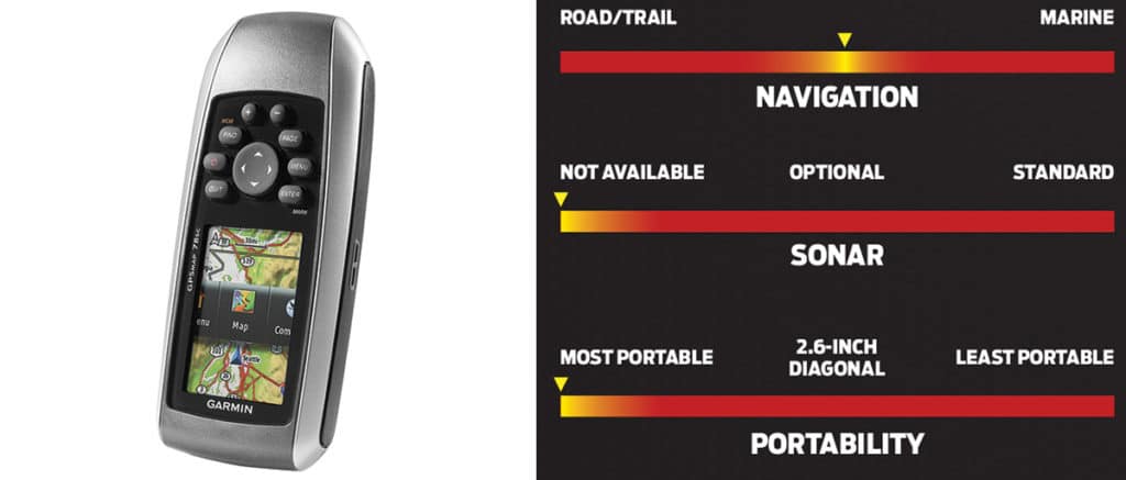
Garmin GPSMAP 78sc
Screen Size: 2.6-inch diagonal
Touch Screen: No
Sonar Capability: No
Waterproof: IPX-7 and it floats.
Media Port: MicroSD
Powered By: Two AA batteries (20 hours)
Nautical Charts Included: World marine and land base map with land and sea features
Optional Charts Available: BlueChart g2 and LakeVü HD, City Navigator, various topographic maps
Dash Mounts: Optional adhesive marine mount
Special Features: GLONASS Russian satellite capable; turn-by-turn capable with City Navigator; Custom Maps system converts paper maps into downloadable media GPS-ready — for instance, you can overlay historic maps over modern maps.
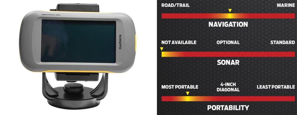
Garmin Montana 600 Marine Bundle
Screen Size: 4.0-inch diagonal
Touch Screen: Yes
Sonar Capability: No
Waterproof: IPX-7
Media Port: MicroSD
Powered By: Three AAs or one lithium-ion battery (included)
Nautical Charts Included: BlueChart g2
Optional Charts Available: City Navigator and various topo/trail maps
Dash Mounts: Standard
Special Features: Add City Navigator maps for turn-by-turn highway navigation or topographic U.S. maps for hiking; Wi-Fi interface enables waypoint and trail sharing between compatible devices — can be used for trading fishing holes or hiking destinations; barometric gauge indicates precise altitude.
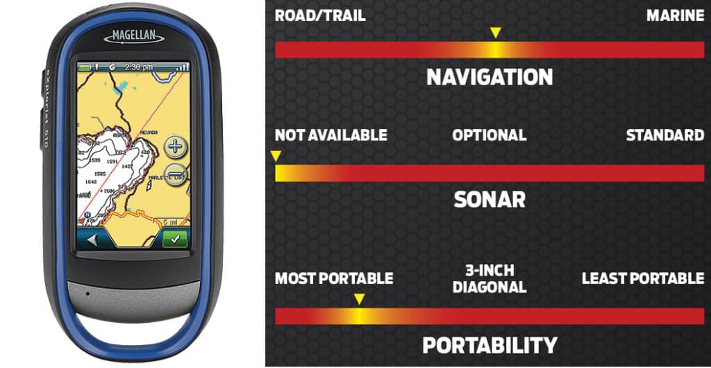
Magellan Explorist 510 Marine Edition
Screen Size: 3.0-inch diagonal
Touch Screen: Yes
Sonar Capability: No
Waterproof: IPX-7
Media Port: MicroSD
Powered By: Three AA batteries
Nautical Charts Included: Navionics Gold SD card, comprehensive coastal and lakes for all anglers
Optional Charts Available: City Navigator and various topo/trail maps
Dash Mounts: Aftermarket rammount.com
Special Features: Magellan Communicator and cable (Mac or PC) allow transfer of user-generated content to Navionics Freshest Data server for updates; 3.2-megapixel camera has microphone for voice memos; two programmable hard buttons let you customize the device, and touch-screen action eases operation.
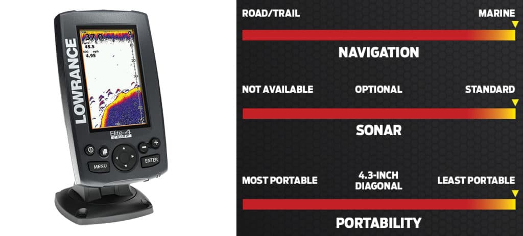
Lowrance Elite-4 HDI
Screen Size: 4.3-inch diagonal
Touch Screen: No
Sonar Capability: Choose 50/200 kHz (to 1,000 feet) or 83/200 kHz (to 3,000 feet) CHIRP with DownScan and overlay for added detail.
Waterproof: IPX-7
Media Port: MicroSD
Powered By: 12-volt power supply
Nautical Charts Included: U.S. background map with lakes and coastal contours to 1,000 feet
Optional Charts Available: Navionics, Jeppesen C-MAP, Fishing Hot Spots
Dash Mounts: Optional adhesive or screw-down mount
Special Features: Distinguish individual fish from cover; upload recorded sonar tracks to Insight Genesis to generate and download custom contour GPS maps; TrackBack scrolls back to sonar readings, allowing user to create target waypoints.
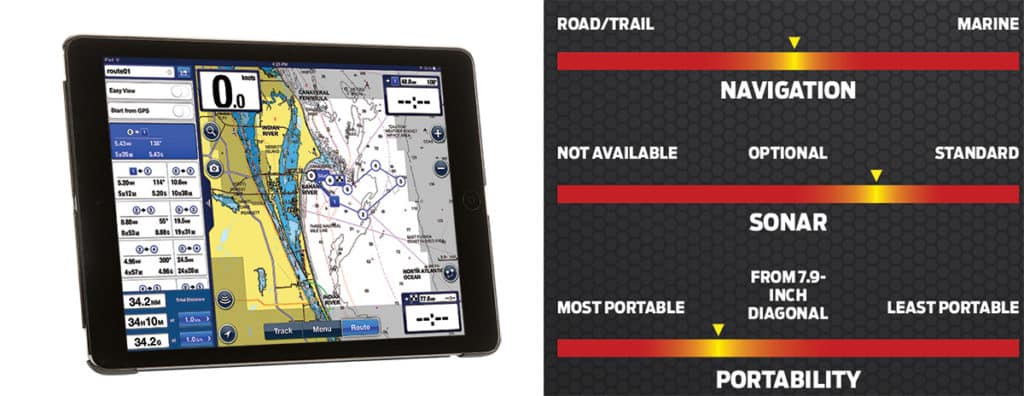
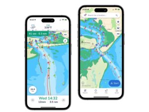
iPad with Navionics Boating
Screen Size: From 7.9-inch diagonal
Touch Screen: Yes
Sonar Capability: Yes, with optional aftermarket Vexilar app and hardware
Waterproof: Not rated
Media Port: USB and Wi-Fi
Powered By: 12-volt power supply
Nautical Charts Included: No
Optional Charts Available: Navionics, BlueChart g2, Jeppesen C-MAP, Fishing Hot Spots, Fugawi apps and maps
Dash Mounts: Aftermarket mounts and waterproof cases are necessary for secure on-water operation.
Special Features: Aside from the things tablets do (camera, video, media, reader, email, business apps and others), you can add apps like Navionics Boating or BlueChart g2 and then use your iPad to set routes and waypoints and navigate them.
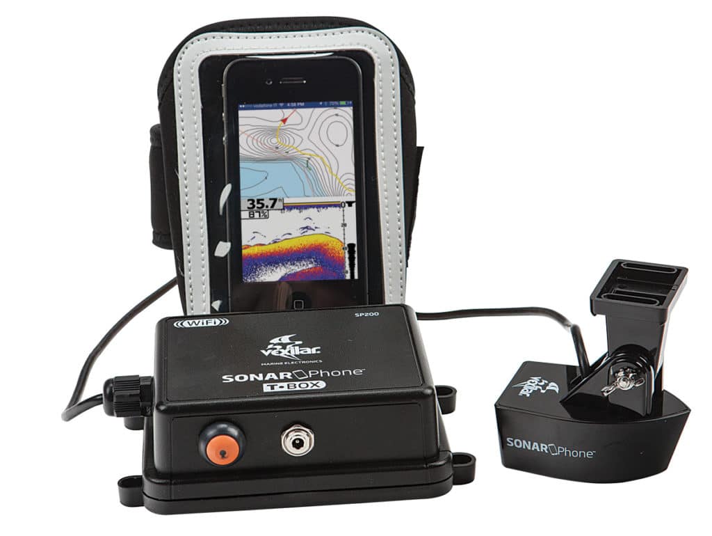
Vexilar SP200
Mount your transducer, hard-wire the black box and connect to its Wi-Fi hot spot to add app-based sonar to a smartphone or tablet. A dual-beam 200/80 kHz transducer reads depths to 240 feet. Even better, it will overlay your sonar trail on the tablet chart in real time, giving you the clearest picture of the bottom, never before available.
Navionics also allows sonar logging via its Freshest Data server. These charts below show an area of the Bahamas both before and after sonar logging updates. The sonar log is rendered and made available to download as an overlay on the chart plotter’s resident chart.