Estimating Your Position
How far are we from shore? In the GPS age, that’s an easy question to answer. But long before there were electronics, experienced mariners had a sea bag full of simple tricks to help estimate their distance and position relative to a given shoreline. You may never need these tricks — unless the GPS goes out — but they are fun to practice and might impress your shipmates.
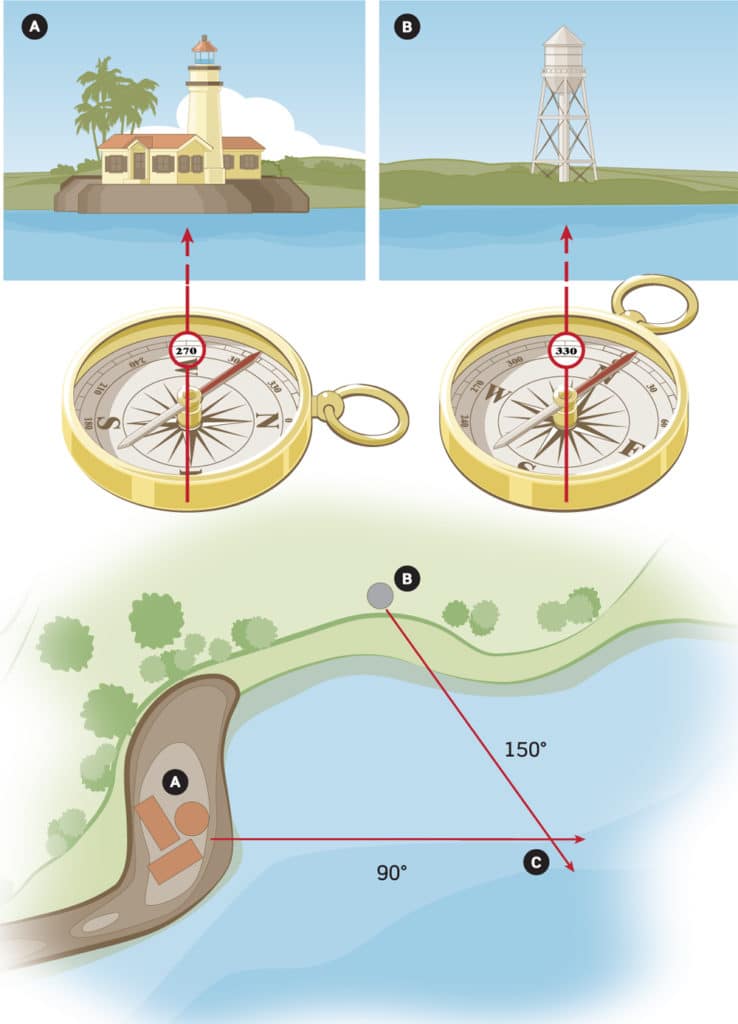
Bearings Fix
With just a chart and a compass, you can get a pretty good fix on your position. Using the center of the compass (your heading) as the first reference point, find a conspicuous landmark on shore as the second (lighthouse) (A). With one eye, follow the sight line from compass center to the landmark, making note of the numeric bearing it intersects on the outer edge of the compass.
Repeat the process with a second landmark (water tower) (B). At this point, you’ll have two sets of bearings: say 270 degrees to the old lighthouse and 330 to the water tower.
Now figure reciprocal bearing (the number on the opposite side of the compass) for each of these. For bearings more than 180 degrees, subtract 180; for less, add 180. (You’d be 90 degrees off of the old lighthouse and 150 from the water tower.) Get out your chart and parallel rules, and using the compass rose, draw bearing lines outward from the landmarks. Your estimated position is where these lines intersect (C).
Eye Blink
An age-old trick for figuring one’s distance from shore requires nothing more than your upraised hand. Pick a landmark on shore and extend your arm with one finger raised. Close one eye and cover the landmark with your finger. Now switch eyes and note that the finger jumps to another point on the horizon.
It just so happens that the distance from your eyes to your outstretched finger is 10 times the distance between your two eyes. Without going into the geometry behind this fact, suffice it to say that distance between two objects measured using the “eye blink” method will be one-10th your distance from those objects. Multiply that eye-blink distance by 10 and you’ll know how far from shore you are.
For example, if your finger begins over a beachfront condo and jumps to a utility pole, you might estimate that the finger jumps five building lengths between condo and pole. If the building looks to be 100 feet long, the “jumped” distance would be 500 feet. Multiply that by 10 to estimate that you are 5,000 feet offshore — just shy of a mile.
Horizon Height
When you’re too far from shore to use individual landmarks, you can still calculate distances using horizon height. If sitting at the helm of a small boat (eyes about four feet off the water), the shoreline will first appear when you’re around 2.3 miles offshore. Make that 3.5 miles if you’re standing at a helm a couple of feet above waterline, and around 4.5 miles if you’re up on the flybridge.
Remember, this is just the distance to the water’s edge. Tall objects such as towers or hills would change the equation. An easy example would be a 100-foot-tall lighthouse. In clear weather, a skipper seated at the helm of a small boat would be 14 miles away when the top of that structure comes into view.
Knowing these simple, traditional mariner’s tricks may impress your boating buddies, but more important, in an emergency situation, they allow you to approximate your position without being totally reliant on that GPS.