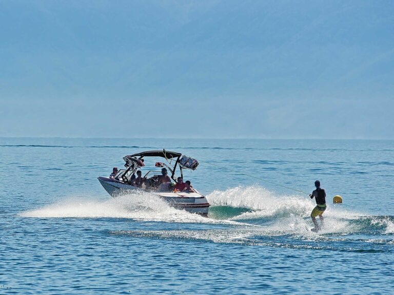
Now I have a color plotter, a fish finder that’s also a GPS, a radar interfaced to GPS and a handheld GPS stashed in the radio box as a backup. But I still use my compass.
For one thing, I find it easier to keep a heading — derived from one of the illuminated pixel machines — by glancing at the compass card than by trying to make the screen icon trace over the electronic bearing line projected to the next waypoint. It looks good zoomed out, but zoomed in to where I can see some detail on the chart, it looks like a snake traversing a tree branch. It’s just not reasonable to expect to steer and maintain a course within 5 degrees of the heading on a small boat, especially if there’s wind, waves or current, and most especially when going slow, as prudence dictates we do when visibility drops. So I find the compass, an analog tool lacking the plotter’s digital precision, is much easier to follow, even if I’m getting the heading from the GPS in the first place. The phenomenon is akin to the way blues sounds better on vinyl than it does on a CD or an MP3 player. Audiophiles know what I mean.
Also, working directly from the earth’s magnetic field means my compass isn’t dependent upon electricity, satellites or software. All three have let me down over the years — sporadically, yes, but it happens. When it did happen, I still had that trusty graduated card spinning on its jeweled pivot to get me home.
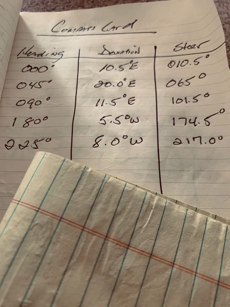
For these reasons, and because I’m a tradition-bound boat nut, I carry a deviation table aboard my boat. What’s that? It’s a chart you can make yourself that shows the error of your compass.
Compass error comes in two flavors. Variation is the difference between true north, at the geographic North Pole, and at the magnetic pole, 427 miles to the southwest. Variation is the same for all compasses in a given area and is noted on the area’s nautical chart in the center of the compass rose. In my area, it happens to be 14 degrees west, meaning I have to add 14 degrees to what my compass reads in order to get an accurate magnetic heading. Much of the variation can be eliminated by adjusting the magnets installed in your compass — or by having that done by a professional compass adjuster. Yep, compass adjuster is a bona fide job title.
Deviation is different. It’s different for every compass, even those aboard boats in neighboring slips. Error from deviation is the result of magnetic forces aboard an individual boat that pull the card around, away from magnetic north. Aboard a fiberglass boat, these include the very electronics we install to ensure accurate navigation. Ironic, huh?
Another big cause of deviation is electrical wiring. Any wiring beneath a helm or within three feet of the compass should have its positive and negative leads twisted to negate the magnetic field that occurs when current-carrying wires are laid in parallel. These create error mostly when the circuits they serve are energized, so it should come as no surprise that the compass light itself is one of the biggest offenders when it comes to deviation.
But I digress. The big thing about deviation is not that it exists, but that, unlike variation, it’s not a constant. Deviation changes on different headings. Unlike its cousin, a skipper can’t simply add (or subtract) a known amount all the time to figure a compass heading. To get the most accurate reading, you need to know the deviation at each and every heading, 0 through 359 degrees. So a table must be made, enabling the skipper to refer to it. For example, if your course requires a heading of 240 and deviation at that heading is 8 degrees, you add the 8 and steer 248 to actually make the 240 required to hit your waypoint. Get it?
Aboard ships, and aboard boats licensed to take more than six passengers for hire, a deviation table is required equipment. But as I said earlier, I am of the opinion that it’s nearly impossible to steer a small boat on open water within 5 or 6 degrees. Try it yourself. If you succeed, let me know.
With that mindset, and my desire to have a fully functioning, nonpowered navigation tool with zero carbon footprint, here’s my recommendation for making and using a deviation table aboard recreational small craft.
1. Since we don’t need one-degree precision, either by law or practicality, make your deviation table using just the cardinal and intercardinal points of the compass. In plain talk, take readings every 45 degrees: N, NE, E, SE, S, SW, W and NW.
2. You’ll need to use a hand-bearing compass to take the readings. A compass engineer would set up a transit between two charted objects, establishing a known bearing, and then have the boat cross that transit at each and every point of the compass to develop a deviation table.
Instead, and still on the assumption that you’re with me for how much accuracy can be practically steered aboard Mom’s Mink, Sea-Joy and Hooker, I use this method aboard Breakaway.
Have a buddy go to the bow with the hand-bearing compass, which is the farthest you can place a crew member away from almost all magnetic interference without banishing him to the dinghy and towing him in your wake. You can remove the anchor to the cockpit if you think it’s a problem.
With Bow Buddy doing his thing, steer the boat by the compass to the cardinal and intercardinal points. Note each one, and have Bow Buddy call out what he reads. Write both headings down and proceed to the next heading. In this way you can develop a deviation table specific to your boat.
What will it show? Aboard my current boat, the compass is within a degree when I head north or northeast; it’s off very little, only about 3 degrees, at southeast and south; at southwest, it starts to get funky, reading 8 degrees off; west is worst, where I have a built-in error of 13 degrees; and at northwest it moderates a bit back to 9 degrees. Though I made the table and wrote it in the notebook that serves as my log, I’ve pretty much memorized the errors now, so steering is a cinch.
Why not use your GPS instead of the hand-bearing compass? Because a GPS isn’t magnetic. It works by triangulation, using speed and present position to deliver a direction. It gives you a COG (course over ground), telling you which way you are going, not which way you are pointing. At any given instant the heading may be right, but since it’s constantly averaging, you can’t be sure. All’s usually well at speeds above 10 knots, but when you slow down, as you would in fog, snow, dark, whatever, the differences between small changes at the wheel and what the display shows can be great. This is one reason why a heading sensor — a gyro or an electronic compass — is recommended when installing an autopilot. But all you have to do to see this inconstancy is make for a waypoint and then compare your track to the velocity made good display. You’ll see that a GPS actually provides headings in tight wiggles rather than straight lines.
Read Next: How To Boat Without Modern Technology
Deviation table in hand, you are prepared to flex your piloting skills and start using the, by gawd, tried-and-true methods of navigation: pencil, dividers, chart, watch and compass. If I’m coming across like the John Madden of charting, that’s because I’m as enthusiastic about this sport of ours as Madden was of his.
Besides the satisfaction of learning a skill, doing something with your hands and generating confidence in your ability to get home no matter what, old-time navigation, like football played on grass and in snow, offers more visceral rewards. One of these is the look on people’s faces when, while regaling them with your tales of derring-do, you recite the mnemonics that help you remember the calculations. My favorite:
True virgins make dull company? Add whiskey. (True, variation, magnetic, deviation, compass, add west [or subtract east].)
Stay safe.