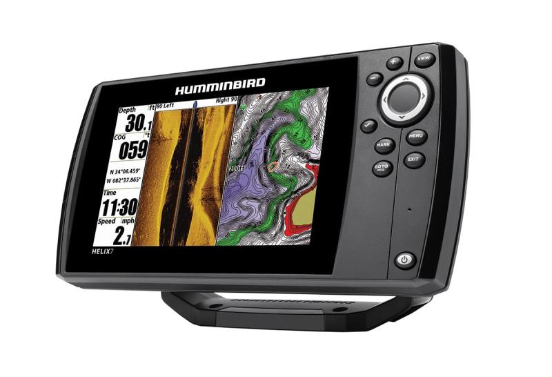
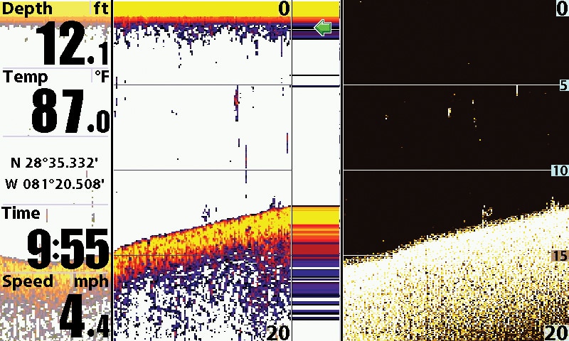
Humminbird HELIX 7 DI GPS
Humminbird HELIX 7 DI GPS
$499
GPS Connection Speed: 2/3
Screen Brightness: 3/3
Pages Access: 3/3
Chart Options: 2/3
The Skinny: Humminbird quietly nibbles away at the competition with new product innovation, great features and a wide screen. It may be too quiet; it’s easy to forget Humminbird was a front-runner with side-scanning sonar and scroll-back features associating GPS position data with sonar data. HELIX 7 DI GPS is a chart plotter and high-definition sonar, boasting down- imaging and a temperature probe, all in one box for a startlingly low price. It is compatible with Humminbird’s AutoChart, allowing users to privately create highly detailed bathymetric maps with sonar data recording with GPS coordinates for each point. Nobody else sees your treasured new spots but you — and your lucky friends. It is both flush-mountable and gimbal-mountable. Easy-to-connect friction cable plugs make removing it for security a snap.
Test Reflections: We ran all units simultaneously, and we allowed auto settings to filter unit-to-unit interference — it had excellent filtering. Its screen gave the brightest and widest field of view of all models. Screen navigation was easy, once we “hid” unwanted views in the menu.
Extra Points: Just press “mark” to create waypoints and simultaneous screen shots — easiest of the test field.
Screen Size/Resolution (Diagonal): 7 inches/480 x 800 pixels
Sonar Recording for Mapping: Yes
GPS Channels: Not available
Down-Scanning: 75 degrees at 455 kHz, 45 degrees at 800 kHz; 350 feet
Standard Sonar: 200 kHz, 455 kHz at 28 degrees; 600 feet
Transducer Type: XNT 9 DIT; transom mount
Water Temp Sensor: Yes
IPX Rating: IPX7
Card Slot: MicroSD
Chart Compatibility: Humminbird UniMap is standard; Navionics Gold/HotMaps, Humminbird AutoChart and Humminbird LakeMaster charting are optional
Storage: 2,500 waypoints, 47 routes with 50 waypoints, 1 million track-log points
Sonar Power Output: 500 watts RMS; 4,000 watts peak to peak
Warranty: 1 year
Screen Shot Capable: Yes
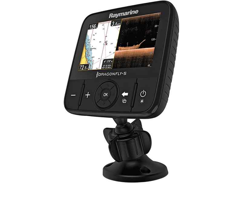
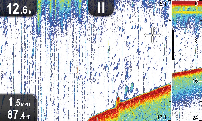
Raymarine Dragonfly 5 Pro Sonar/GPS
Raymarine Dragonfly 5 Pro Sonar/GPS
$599
GPS Connection Speed: 2/3
Screen Brightness: 2/3
Pages Access: 2/3
Chart Options: 3/3
The Skinny: The Dragonfly series is Raymarine’s new answer for small-boat operators who need Raymarine’s professional technology in a small dash-top package. The high-resolution screen is crisp. Raymarine’s LightHouse system interface is easy to use and logical to learn — earning the industry interface buzzword intuitive. Both CHIRP sonar (1,000 feet) and CHIRP DownVision (600 feet) are easy to bring up and interpret. Dragonfly receives Russian GLONASS satellites as well as U.S. GPS satellites. This is the only unit in this class boasting Wi-Fi to tablet or smartphone connectivity to allow sharing of screen content with crew on their Wi-Fish app-equipped device. More impressive, the device can display a different sonar pane than what is visible on the Dragonfly, and you can command the system via a connected smartphone. You can create your own bathymetric charts using the optional Navionics SonarChart Live app.
Test Reflections: The free Wi-Fish smartphone/tablet app worked great, giving remote controls and an additional display. Selecting menu pages was made complicated by a time lag between the key command and its appearance on the screen. Once we got the timing down, and waited, the interface was logical, still earning its “intuitive interface” praise. The screen was crisp and clear but slightly dimmer than its competitors’.
Extra Points: Dragonfly’s single, combined transducer/power wire is almost as easy to remove and replace as it would be with Garmin’s snap-in mount. The ball-joint mount can face any way.
Screen Size/Resolution (Diagonal): 5 inches/800 x 480 Wide VGA
Sonar Recording for Mapping: Yes, with Navionics SonarChart and SonarChart Live
GPS Channels: 72
Down-Scanning: CHIRP, 60 degrees at 600 feet (frequency unpublished)
Standard Sonar: CHIRP, 25 degrees at 900 feet (frequency unpublished)
Transducer Type: CPT-DVS DownVision; transom mount
Water Temp Sensor: Yes
IPX Rating: IPX6 and IPX7
Wi-Fi: Stream to tablets or smartphones
Card Slot: MicroSD
Chart Compatibility: Navionics+, C-MAP and Raymarine LightHouse vector and raster charts
Storage: 3,000 waypoints, 0 routes, 15 tracks with 10,000 points (addtional storage with microSD card)
Sonar Power Output: Not published
Warranty: 1 year
Screen Shot Capable: Yes
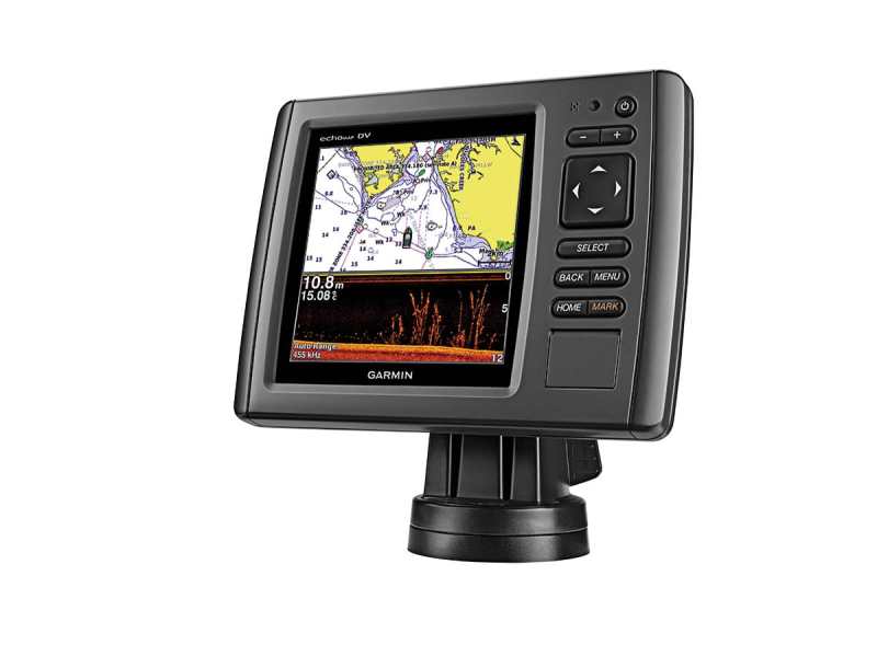
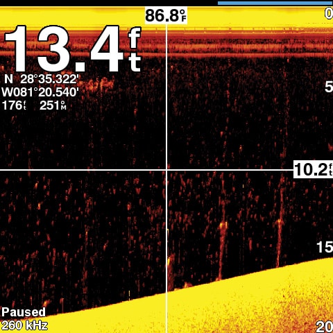
Garmin echoMap 54dv
Garmin echoMap 54dv
$499
GPS Connection Speed: 3/3
Screen Brightness: 3/3
Pages Access: 3/3
Chart Options: 2/3
The Skinny: This unit addresses both U.S. GPS and Russian GLONASS positioning satellites for added accuracy. Enhanced Auto Guidance chooses your route based on destination, draft and bridge clearance, avoiding charted hazards — all you do is tell it where you want to go and it plots the most direct, safe course to your destination. It supports AIS and has onboard tide tables. Social mapping is enabled by overlaying sonar tracks on top of Google Maps. Track logging is viewable on the optional Home Port trip-planning app that allows integration of sonar data into Google Maps. A single CHIRP transducer supports DownVü and traditional HD-ID sonar. DownVü scanning employs a wide port-to-starboard beam that sweeps bottom structure like a wide paintbrush, rendering the lifelike images of structure and fish. Auto gain and sensitivity settings were ideal.
Test Reflections: User interface is easy to learn and remember. The home button brings up the main menu, and logical selections are listed and easy to select with the toggle button. Its GPS receiver is so strong it attained position fix nearly instantly — under a roof.
Extra Points: Garmin’s echoMap 54dv offers the only snap-on, snap-off gimbal mount for easy removal and secure storage. It swivels for optimum viewing angle and can turn 180 degrees, allowing visibility from the bow, stern or helm.
Screen Size/Resolution (Diagonal): 5 inches/480 x 480
Sonar Recording for Mapping: Yes, appends Google maps
GPS Channels: 12
Down-Scanning: CHIRP, 260/455 kHz, 1,100 to 2,300 feet, 30 to 51 degrees
Standard Sonar: CHIRP, 50/200 kHz, 29 degrees, 1,100 feet/salt water; 2,300 feet/fresh water
Transducer Type: GT21-TM; transom mount
Water Temp Sensor: Yes
IPX Rating: IPX7
Card Slot: MicroSD
Chart Compatibility: BlueChart g2 coastal is standard; g2 Vision and LakeVü HD Ultra, optional
Storage: 5,000 waypoints, 100 routes, 50 tracks with 50,000 points
Sonar Power Output: 500 watts RMS; 4,000 watts peak to peak
Warranty: 1 year
Screen Shot Capable: Yes
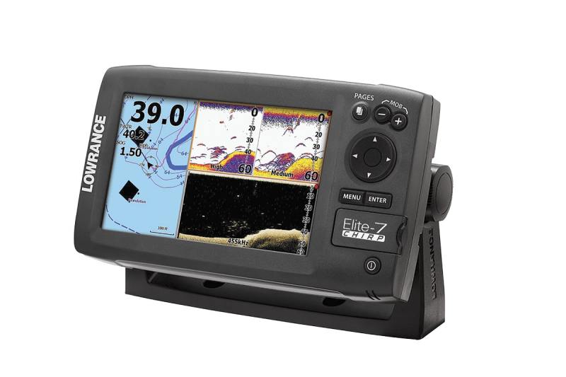
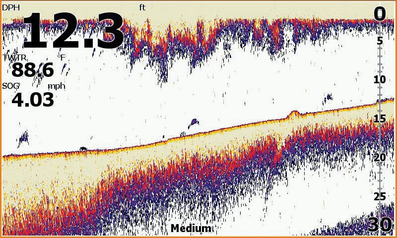
Lowrance Elite 7
Lowrance Elite 7
$599
GPS Connection Speed: 3/3
Screen Brightness: 3/3
Pages Access: 2/3
Chart Options: 3/3
The Skinny: Lowrance chart plotters keep getting more powerful and richer in features, but smaller and lower in price. Navigation versatility comes from its compatibility with the widest selection of digital charts, and they’re easily purchased online from the GoFree store. That lets the skipper choose the charts that suits his or her navigation style. Standard sonar beam with the penetrating return of CHIRP sonar can be easily enhanced with an optional DownScan HDI transducer. Social charting through the GoFree store online is extremely user-friendly, enabling boaters to create astonishingly detailed charts with their recorded sonar readings. With TrackBack, scroll the sonar screen back and touch any sonar structure to immediately create a permanent GPS waypoint.
Test Reflections: Its wide, bright screen brings great value. It wouldn’t surprise us to see a price reduction in the face of competition, perhaps making DownScan standard instead of optional. Sonar readings were crisp, bright and clear. Navigating screens via the Pages button offered clear access to the views we wanted. An exit key to leave cursor mode or to “Find Ship” would streamline the interface.
Extra Points: GoFree store gives free access to custom maps created with sonar recordings; upload and download via a microSD card. It was quick to get a GPS fix even when it was under a garage roof.
Screen Size/Resolution (Diagonal): 7 inches/800 x 480
Sonar Recording for Mapping: Yes, via GoFree store
GPS Channels: 16
Down-Scanning: CHIRP, optional
Standard Sonar: CHIRP, 83 kHz, 200 kHz at 22 degrees, 1,000 feet
Transducer Type: HST-WSBL; transom mount
Water Temp Sensor: Lowrance HDI 83/200, 455/800
IPX Rating: IPX7 u Card Slot: MicroSD
Chart Compatibility: Lake Insight and Nautic Insight Pro and HD, Navionics Gold and HotMaps Premium, Fishing Hot Spots Pro and Jeppesen C-MAP MAX-N
Storage: 3,000 waypoints, 100 routes, 100 tracks with 10,000 points
Sonar Power Output: 500 watts RMS
Warranty: 1 year
Screen Shot Capable: Save to microSD
Social Mapping Capable: Yes
Not everyone needs a chart plotter with a 12-inch touch screen, backed by six black boxes and networked to two or three more displays. Sometimes, a single, simple screen on the dash with sonar and GPS is elegantly functional. In reviewing the marketplace, we identified units with far more than just a chart and sonar reading. We found four for under $600 and matched them up to help you decide what you need.
How We Tested
Points of Comparison
Here are specifications that we think are most important:
•More GPS channels means quicker start-ups and enhanced reliability, but our tests revealed that some with the most channels didn’t connect up first.
•Social mapping or sonar recording allows users to make their own far-more-detailed bathymetric maps of their favorite waters.
•With screen size, bigger is better.
•The brighter the screen the better.
•Down-scanning takes a 50- to 60-degree fan-shaped scan of the bottom with a signal that is only about 2 inches wide, providing fantastic detailed bottom imaging of structure.
•Most inland boaters don’t need to scan 600 feet or more, but the ability to do so reflects the power of the system and its ability to capture targets.
•Memory size of each unit is reflected in the number of waypoints, routes and tracks it can record. Only Raymarine allowed storage to overflow to a microSD card.
•Screens can be polarized, blocking your image when wearing polarized sunglasses — none of our displays exhibited significant impediment and were not scored.
•Viewing angles once were narrow — these units were all readable from any practical viewing angle.
How We Scored
GPS Connection Speed: We checked the time to achieve a GPS fix. Faster is better. The fastest got three points.
Screen Brightness: The brightest scored three points.
Pages Access: This is a bit subjective, but usually fewer button taps to a particular screen equated to easier accessibility. The easiest access received three points.
Chart Options: We think more chart options are better, allowing versatility for users. Offering Navionics plus C-MAP options earned three points.


