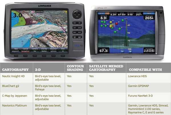
Boaters are accustomed to miracles in navigation equipment, patting the chart plotter lovingly for its loyalty in bringing them home or finding a marina when fuel is low. Yet there’s often an unsung hero hidden within a card slot or spinning on an internal hard drive — the cartography. It’s actually a partnership of hardware and software that makes the magic. most chart plotters are equipped with a base map, but for more clarity in navigating information, upgrade to top-shelf stuff that lets you take advantage of GPS power to optimize and customize the chart view for a clearer and more realistic view of the road ahead. Here are some of our favorite features and who makes them.
Custom Shaded Danger Zones
A pioneer in user-optimization was Raymarine, which several years ago began presenting software in its e-series chart plotters, allowing users to change depth shading on Navionics’ platinum charts. While 60 feet is the National Oceanic and Atmospheric Administration danger line (that depth and shallower is shaded a darker blue on government charts), most recreational boaters worry only about water less than 20 feet deep. Recently, Furuno partnered with C-Map, and Garmin tweaked its BlueChart g2, to allow adjustable danger zones too — and let you shade them in bright orange or red, if you choose. Lowrance and Simrad offer similar optimization.
3-D Contour View
Powerful microprocessors enable more and more information to be combined into charts. Our favorite feature is the 3-D look at bottom contours. With it, a two-dimensional chart is rendered into a dramatic and graphic view of humps, canyons and shoals, bringing clarity to the navigator’s decision-making process (it also helps boaters spot fish-holding structure). Garmin offers a unique fisheye 3-D view that gives an underwater vantage point and pinpoints sonar targets that could be fish. 3-D adjustments allow a perspective shift from sea level to bird’s-eye view. Top players are Furuno, Garmin, Lowrance, Simrad and Raymarine.
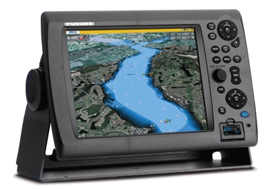
Satellite View
Merging satellite photography with navigating cartography gives boaters a view of the water miles ahead, akin to Google street-view maps online. Photography and cartography merge so seamlessly and realistically that looking at the screen makes you feel like you’ve already been there. Yet all the nav data of depth, channel and markers remain. Toggle between sea level views or bird’s-eye views.