Free or darned cheap apps for boaters (and some for anglers) are scattered all over the web, and we’ve been sorting through them, looking to separate those that are worth no more than the price paid from those we think could be priceless.
Some of our chosen apps are fully free, and others offer basic but valuable tools in the free version. For upgrades, we advise when to trigger a paid upgrade or when to continue freeloading.
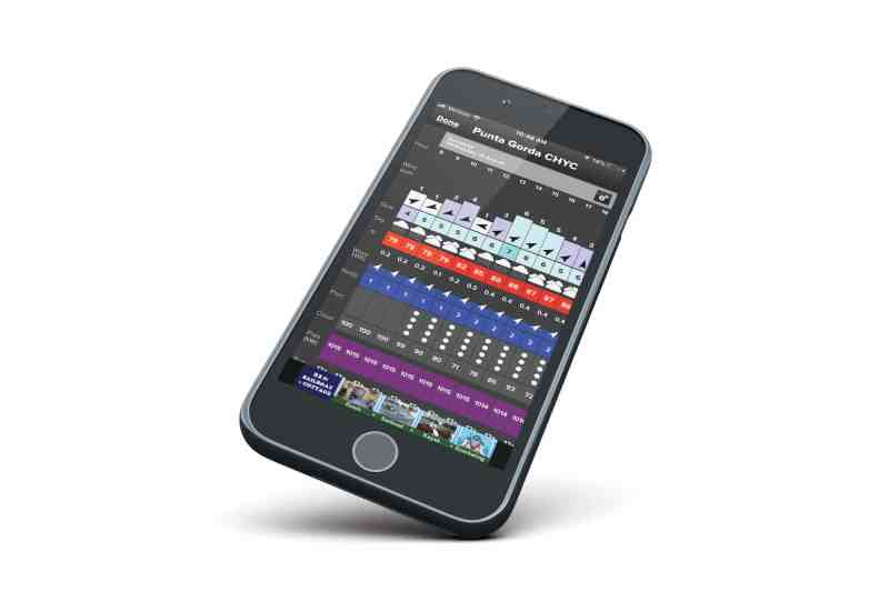
Fish Weather, 4.6 Stars
The free app reports wind speeds in graph form based on the nearest weather station to your actual location, or a selected location. The forecast table is this app’s effective tool, giving current and forecast wind speed, plus gusts, wave height and period, precipitation and temperature. The free data also includes local tides at stations sorted by your choice of either alphabet or distance. Radar overlay on the chart identifies storm cells and reporting weather stations. In addition to radar overlays, the standard version offers wind-direction overlay for any selected region.
Upgrades and More: Pro, Pro Plus and Gold upgrades (from $3.99 to $14.99 monthly) add options such as ocean currents and sea-surface temperatures, along with detailed NOAA forecasts (which are actually available from NOAA for free on its website).
Our Take: We liked the way the data was served up on the free app features. An upgrade to Pro ($3.99 per month) would be our next stop for sea-surface temps and ocean currents.
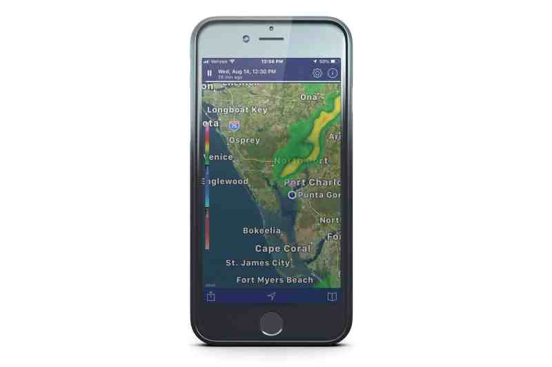
NOAA Radar Pro, 4.7 Stars
Less than five bucks, but priceless, the NOAA-driven radar app displays and animates the last 30 minutes of radar tracks, allowing the user to project the upcoming 30 minutes. Tap the map and a location pin pops up. Tap that to access the local seven-day weather forecast, including wind, waves and precipitation.
Upgrades and More: There is a free version with annoying pop-up ads and a somewhat more confusing display of data, but we felt the $4.99 upgrade was worth it for the cleaner presentation. The Pro service eliminates advertising, which pops up on the screen, sometimes blocking information.
Our Take: This a top radar reporting app that includes full weather. However, it does not provide mariners needed sea-state data. We wondered, why not?
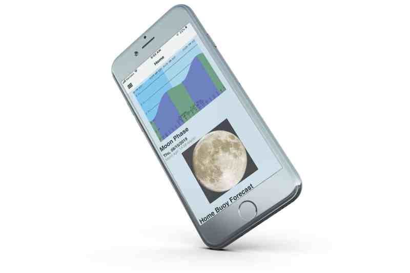
NOAA Buoy Data, 3.6 Stars
Called NOAA Weather Buoy on the iTunes store, we were surprised this free app only got 3.6 stars. Use your smartphone’s location services to find the weather buoys near you, and instantly read up-to-date information on wind, wave height, period and more. Set your home buoy to give you the buoy weather and tide graph from the nearest stations. It will also give local tides from your nearest tide station. Moon rise and set, plus sunrise and set are also displayed, so you can easily plan your day on the water.
Upgrades and More: There are no upgrades to this free app, but there are other nice features to it for free. Fishermen and navigators who care about moon phases can predict the ideal date for a romantic moonlight cruise, and anglers can choose the more productive dark moon phase to focus their fishing. Use it to look ahead in anticipation of a trip in a week or a month or a year—the data is all served up in the app.
Our Take: NOAA earns your tax dollars with this free app, and it is a regularly used tool in our boating and fishing kit.
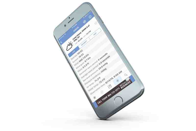
NOAA Buoys Live Marine, 4.3 Stars
All NOAA weather buoys pertinent to boaters are located on the map. You can sort them visually or by using location services in your smartphone to select the nearest buoys. Set “favorites” to quickly access that information. Some buoys don’t offer up full data, or the full data isn’t reported to the app developer, per its disclaimer. We checked several buoys to see that full data included wind, waves, period, sunrise and more—some did, some did not.
Upgrades and More: You’ll get advertising on this app, and we didn’t see an option to upgrade beyond the free app. Sorting buoys by map, nearest location, or marking favorites adds efficiency.
Our Take: NOAA has an exhaustive collection of buoys, but the Buoy Data app included data from private sources too. NOAA will be best for offshore and Great Lakes mariners, but inland boaters will want to use the Buoy Data app as a companion to it because it also accesses local and private weather stations where available.
Fishbrain, 4.7 Stars
The Fishbrain developers partnered with Casio watches to develop this most easily used social app for anglers. Integration of the Casio smartwatch and iOS or Android phones or tablets allows anglers to verbally report a catch, its location and more by talking to the Casio Pro Trek smartwatch using Google Assistant. On the app, a map of your locale includes flagged and reported catches, along with angler, date and bait. Marine services, boat ramps and tackle retailers are also flagged on the map.
Upgrades and More: Upgrading to Premium ($9.99 monthly or $74.99 yearly) gives access to crowdsourced sonar maps via C-Map and unlocks more angler info for sharing and learning. Trends in lures are easily tracked, and there is, naturally, a Fishbrain store to buy mail-order tackle.
Our Take: The app is well-designed, and the free version offers plenty of angler social sharing and works well without the Casio smartwatch. The upgrade price seems steep, until you note the integration of C-Map fishing maps and other data.
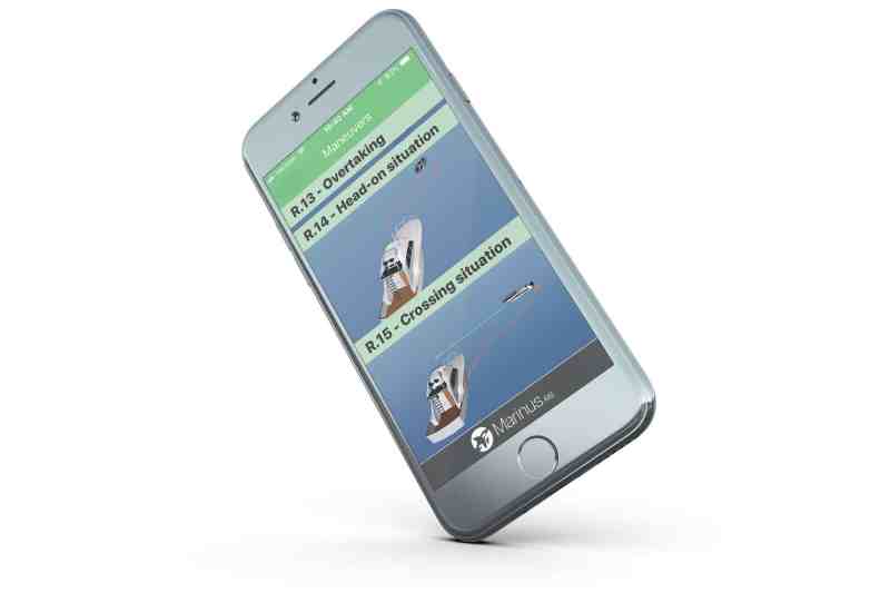
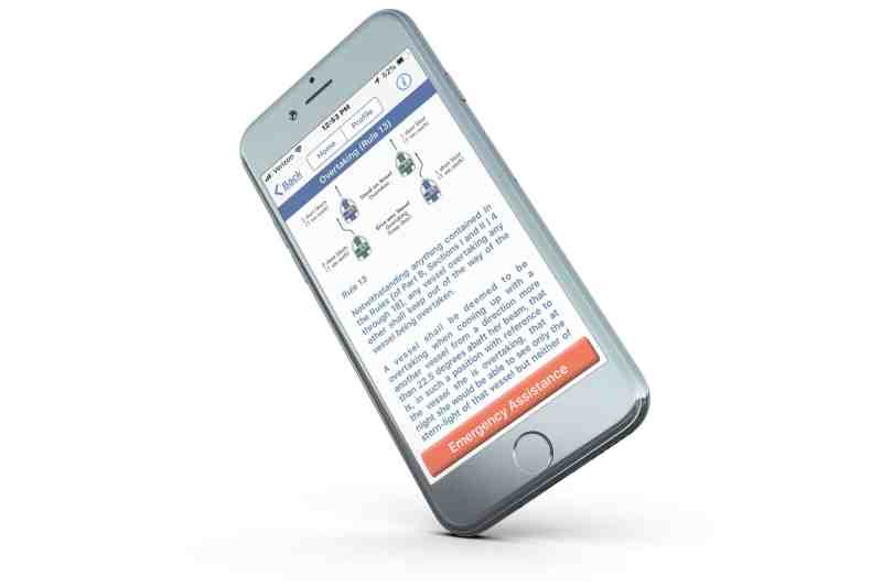
Marinus Lite, 4.5 Stars
The app dishes up the International Navigation Rules in an easily searchable manner that requires only a couple of logical button taps to get to detailed rules for traffic management, buoys, lights, horn signals and more. The references are visual, and the navigation rules are pared down to the essentials so that onboard decisions can be clarified in a time of doubt. Easy references to shapes, flags, sound signals, buoys and aids to navigation, and basic rules for navigation mean you’ll want to keep it handy to win a bar bet or argument with a cranky boater.
Upgrades and More: In-app purchases—$8.99 for the full version with more detailed rules, maneuvers and aids to navigation.
Our Take: The app’s navigation for -“return” or “back” is nearly invisible at the top of the screen, leading to confusion on how to return to the home screen. On the winning side, the most common maneuvering rules are illustrated, giving quick references for meeting, overtaking, crossing and more.
United States Coast Guard, 3.2 Stars
Why the low rating? We don’t know—it could be one of the best safety and information apps available for boaters. The U.S. Coast Guard app puts every safety tool available online in this app. NOAA weather buoys are easily accessible. Enter your profile information, including vessels and descriptions, and use it to quickly file a float plan with trusted friends or family. Tap the icon for Rules of the Road to settle a bar bet on right of way in a heartbeat.
Upgrades and More: This app is self-contained and further provides links to state boating regulations so local boaters can comply with local rules. If you haven’t passed a vessel safety check, schedule one here and go with the confidence of having a Coast Guard-approved vessel.
Our Take: Your taxes paid for it. It’s a darned useful app, so download it, and start filing float plans and disembarking with the full knowledge of the Coast Guard in your smartphone.
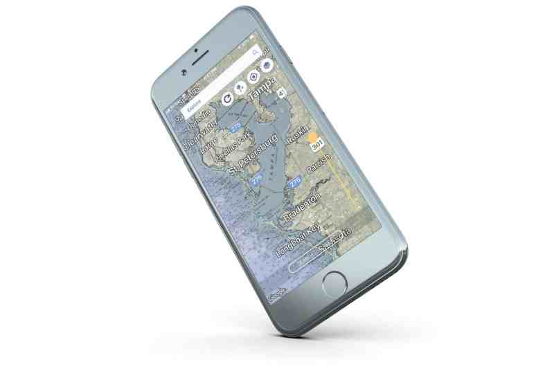
RaftUp, 4.4 Stars
Use it to hook up with friends on your favorite waters or send an SOS along with your location. Create your profile, and make your location on your waterways public, or share only with friends on the app. Quickly send an SOS at the swipe of a slider, and first responders can track you via the app. Check with local LEOs to see if they use RaftUp, but we’ve found many do. The hot ticket on RaftUp is it’s the only free app we’ve found that allows NOAA navigation charts to overlay on the Google map.
Read Next: How To Make A Floating, Waterproof Cell Phone Case
Upgrades and More: You don’t need to upgrade this app for anything. It even gives weather and tides for your location, or selected locations for planning travel.
Our Take: We almost neglected to report on this app because we introduced it to Boating readers last year. However, the navigation chart and tide services have made this valuable app gold-plated, in our opinion. We’ve also heard credible reports of lives being saved by this app when used by boaters and local LEOs.


