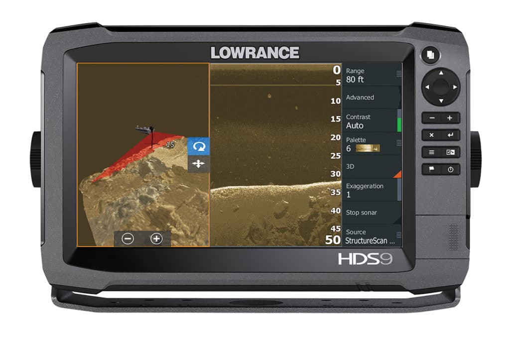
We’ll say it right up front: With StructureScan 3-D sonar from Navico, you peel back the water on a Lowrance or Simrad multifunction display (MFD) to reveal fish, weeds, ditches, wrecks and whatever else lurks beneath the water’s surface — all around you. When I saw it, I struggled not to applaud. It is that good.
Some of our readers might remember being impressed with the first paper graphs introduced in the 1970s. They offered only a thin slice of that coverage without context of its surroundings. Thirty years later side-scan sonar gave a 2-D look at the bottom that was — and still is — revolutionary. Compatible with Lowrance HDS Gen3 (left) and Simrad NSS and NSO evo2 MFDs, StructureScan 3-D matches GPS points to each sonar ping and interprets the data through a powerful black-box processor to render a bathymetric map of your fishing area. (Think The Hunt for Red October.) And, as with standard sonar and side-scanning sonar, the data can be recorded and incorporated into your own new custom GPS chart through Navico’s GoFree online store.
You can tilt the image from 2-D down scanning to 3-D scanning. The system colors the leading edge of the sonar sweep, so you can discriminate the immediate echo returns from the historical 3-D map. The system also “paints” fish and cover in a contrasting color. What’s missing? Well, we bet it’s possible to use this to tell the GPS-guided trolling motor to put your boat in the perfect casting range of the fish identified. We’re not there yet, but when we are — I’ll have to stand up and applaud. ($999 for add-on module and transom-mount transducer.)