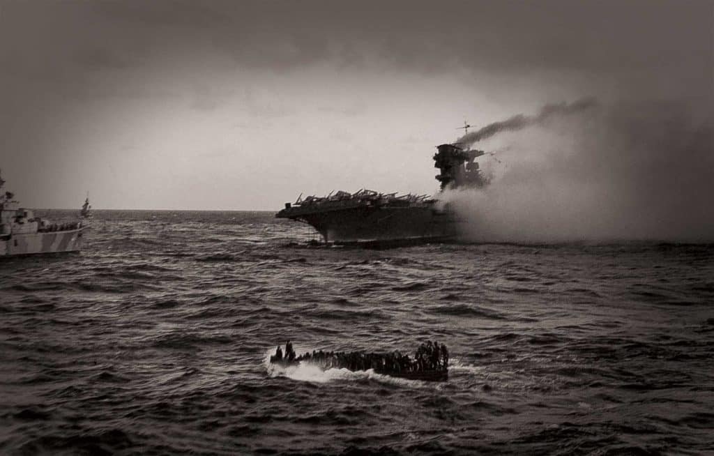
On May 4, 1942, a fleet of aircraft carriers and destroyers from the Japanese navy set out to seize Port Moresby on New Guinea, and therefore take control of the Coral Sea. A fleet of American ships, including the aircraft carrier the USS Lexington, moved in to stop them, thus sparking the four-day Battle of the Coral Sea, regarded as the first air-sea battle in military history. It was also the first time that opposing ships engaged each other without ever having their targets within sight.
The USS Lexington, also known as the “Blue Ghost,” launched its planes into combat during the battle, helping the Allied forces to successfully repel the Japanese before taking direct hits from two Japanese torpedo bombers. Her crew, despite taking heavy losses, managed to contain the fires from those torpedoes as well as additional fire from other Japanese dive bombers. On May 8, four days after the battle began, an uncontrollable fire overtook the Lexington, forcing her commander to abandon ship. After many of the surviving crew were rescued, the USS Phelps, a destroyer, fired five torpedoes into her side to sink her. While the U.S. Navy celebrated its strategic victory over the Japanese, which would set the stage for winning the Pacific Theater in World War II, the Lexington descended to her watery grave nearly 2 miles below the surface, never to be seen again.
That is, until last March, when the R/V Petrel, a research vessel owned by Paul Allen, the co-founder of Microsoft, discovered her on the Coral Sea floor using some cutting-edge technology. The Lexington is just one of several historical finds undertaken by Petrel thanks to its search equipment armed with sonar technologies capable of scanning the depths in incredible detail.
Search and Discovery
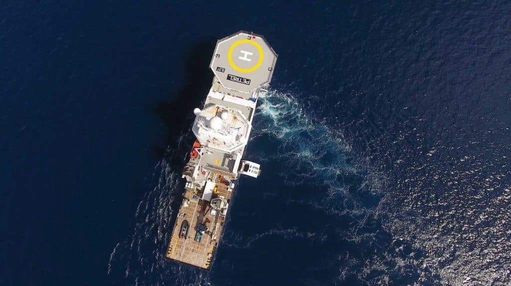
The team that searched for the Lexington and other lost ships works on Paul Allen’s Petrel, a 250-foot former IMR vessel from the oil industry that was designed to handle rugged maintenance duties for offshore drilling stations. When Allen purchased Petrel in 2016, it already had a built-in dynamic position system and was rigged to undertake launch and recovery operations, which proved ideal for handling remote operated vehicles. Allen’s team refit it with state-of-the-art electronics and communications. Once ready, the crew of Petrel set out to find these lost historic ships, being the only privately owned research vessel capable of examining depths exceeding 19,000 feet.
“Mr. Allen has a longtime interest in history and marine archeology,” says David Reams, the senior director of maritime operations for Petrel. “The discovery of ships such as the Lexington bring their history and the sacrifices of their crew back into the public eye.”
Last summer, Allen’s crew used Petrel to locate and photograph the USS Indianapolis, sunk during the last days of World War II in the Philippine Sea. The ship had just completed a secret mission to deliver parts for “Little Boy,” the first nuclear bomb dropped in wartime. En route to safe harbor in the Philippines, the Indianapolis took two torpedo shots from a Japanese destroyer and went down in just 12 minutes. While 300 crewmembers were lost with the ship, a reported 900 went into the water. When Navy search planes located them four days later, only 316 had survived. (Quint, the infamous captain from the movie Jaws, told a harrowing survivor’s account of battling weather, dehydration … and sharks.)
After covering a search area over 600 square miles, Petrel located the Indianapolis 18,000 feet below the surface. Months later, Petrel‘s 16-member crew used the same technologies to locate the Lexington.
What’s the Frequency?
While the mission to locate the Indianapolis lasted several days and covered hundreds of square miles, to find the Lexington, the Petrel crew needed just one day. Because she was sunk on purpose by the Navy, Allen’s team had an accurate report of where the aircraft carrier went down. Scanning a specific area of the Coral Sea, Petrel covered around 18 nautical square miles.
“We located the Lexington on the final line of the first day’s AUV search pattern,” says Reams.
AUV stands for autonomous underwater vehicle, in this case a yellow cigar-shaped Hydroid Remus 6000. The 12-foot-6-inch-long vehicle weighs in at about 1,900 pounds and can operate in depths over 19,600 feet for up to 22 hours. While the Remus 6000 has several state-of-the-art features for navigation and communications back to Petrel, its most important technology is its dual-frequency sonar. It uses side-scan sonar, which maps and records low-resolution 2D imagery by shooting beams from its transducers up to 1,000 meters at 23 kHz both outward and downward. The Petrel crew then commands the AUV to crisscross the designated search area in a grid pattern, hoping it will send images that match their desired target back to them in the ship’s control room.
Once an object is located and the AUV is put in position, the AUV uses a multibeam sonar at 75 kHz to produce high-resolution 3D images that can map a target with extreme detail.
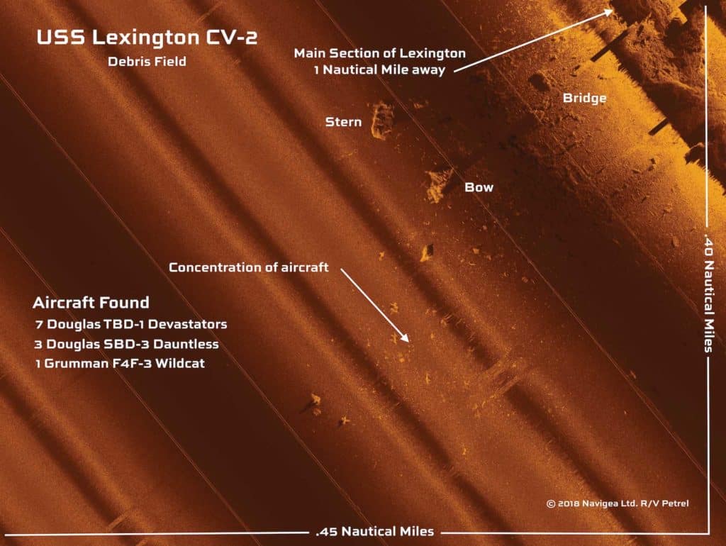
The AUV mapped an area around 0.4 by 0.45 nautical miles. It produced an image that confirmed what Petrel was looking for: a vast debris field that included the aircraft carrier’s main section, bow, stern and bridge, as well as 11 aircraft, including seven Douglas TBD-1 Devastator torpedo bombers, three Douglas SBD-3 Dauntless dive bombers and one Grumman F4F-3 Wildcat fighter.
“Once you start seeing it on sonar, that’s kind of the final piece of the puzzle,” says Paul Mayer, the pilot and researcher for Allen’s crew, in a video interview. “After that, it’s getting a good survey of the area and ROVing.”
ROV refers to the ship’s remote operated vehicle, in which a joystick-controlled unit descends to the seafloor to capture video and photos. Once those came back to the surface, the ship’s crew had no doubt they had found the long-lost Lexington.
Eyes Underwater
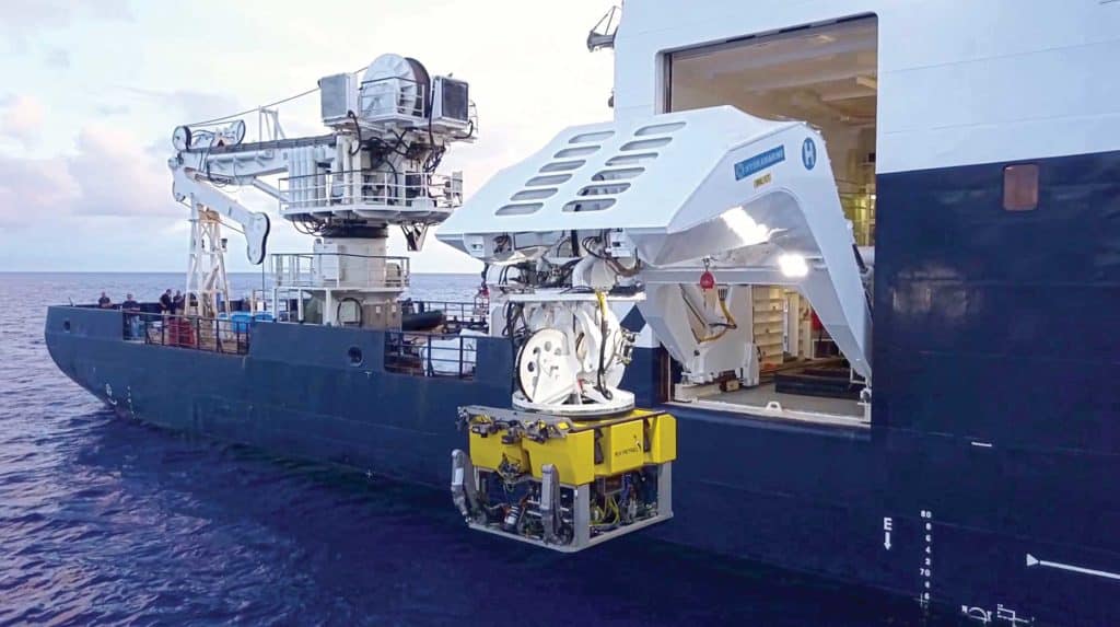
The ROV the Petrel crew uses is an Argus Bathysaurus, also capable of descending over 3 miles below the surface. It has the look and shape of a large genset with robot pincer arms, weighing in at nearly 6,400 pounds. When lowered into the water using Petrel‘s heavy-duty davit, it remains tethered to the ship with an umbilical cable that both provides power and a connection to the control center. It too uses sonar, in this case short-band sonar specifically to help provide range and bearing to the team as the ROV approaches a target. Which, even with all of the modern technology, is not easy.
“We’re dealing with an environment that is very harsh,” says Robert Kraft, director of Petrel‘s subsea operations. “It is thousands of meters deep, and it’s very unpredictable.”
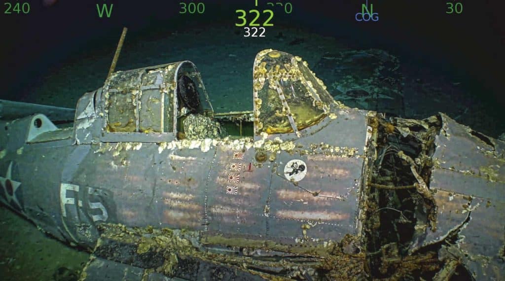
In order to send the ROV down to a target that’s miles under the surface, the crew needs to work with extreme patience while manipulating the joystick in the control room. The Argus Bathysaurus ROV has heavy-duty fiberglass framing to withstand the increased pressure, as well as horizontal and vertical thrusters and a gyro, among other gear. To see beneath the water, the ROV has nine cameras for viewing and locating the target. Once the target is located, it has an HDTV video system capable of livestreaming 1080i HD video to the surface through the cable umbilical cord. It is through these images that the Petrel *crew brought the images of the wreckage of the *Lexington to the surface.
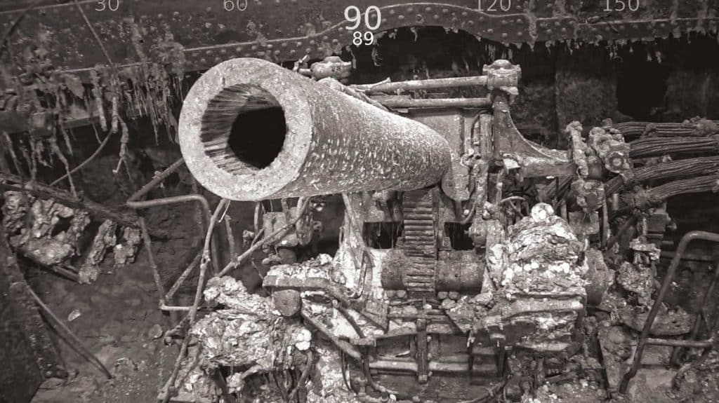
Through the photos and videos, we could see large and intact sections of the carrier, with the name Lexington stamped into the steel on the stern, as well as anti-aircraft guns and a turret-mounted gun with a 5-inch barrel that appears in the video as if we are swimming up to it with a snorkel. We can see a largely intact fighter plane with the Air Force insignia — a red circle inset into a white five-point star inset into a blue circle. One of the planes even showed four Japanese rising-sun flags on its fuselage, indicating four confirmed dogfight kills. The imagery is stunning, and it would not be possible without teams like the Petrel crew using advanced technologies to deliver it.
After the Lexington, the Petrel crew went on to locate and video the USS Juneau and the USS Helena before heading back to their home port to reboot for the next mission. With every undertaking, they are bringing a bit of history back from the depths.
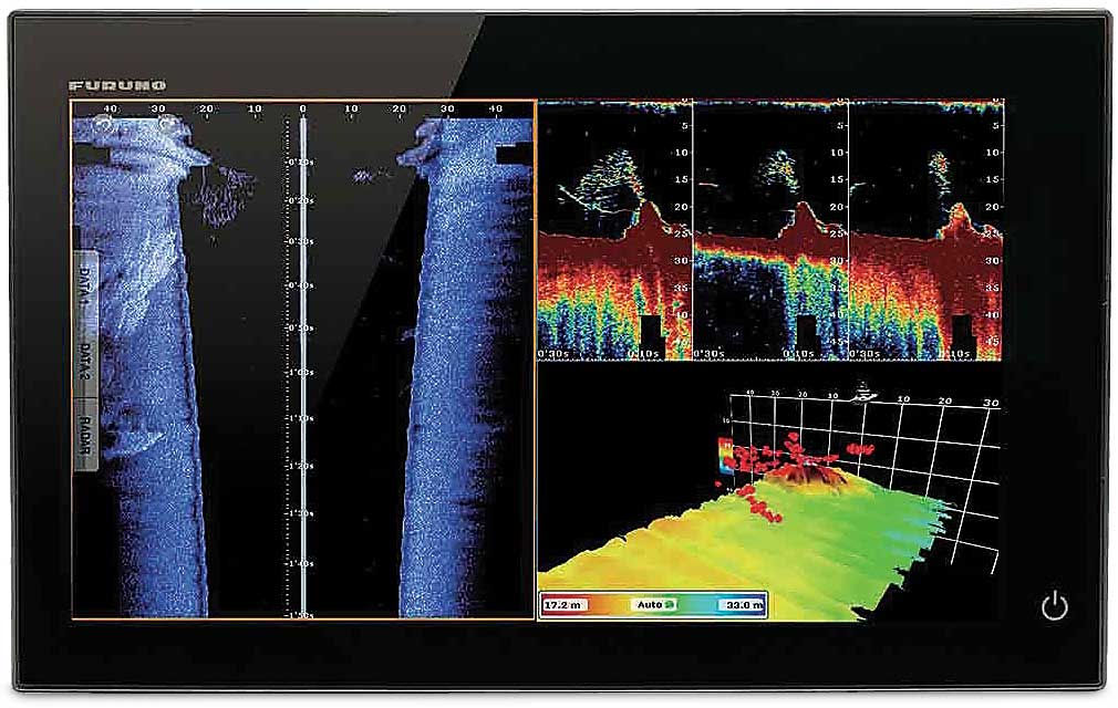
The Recreational Explorer
Don’t have room on your boat for a gigantic AUV or ROV? You can still get detailed imagery of your local seafloor with either chirp or sidescan sonar, with companies such as Simrad, Lowrance, Garmin and Humminbird offering accessible versions of both. One cool multibeam sonar system to check out is Furuno’s DFF-3D, a phased-array system that reads to the side, as well as up and down. Coupled with Furuno’s compact Thru-Hull or Transom Mount multibeam transducer, it can produce traditional fish-finder graphs, imagery to either side of the boat, and detailed 3D images of the ocean floor. It has sidebar detection up to 650 feet over 120-degree swaths, and its main beam can penetrate to over 980 feet directly under the boat. While that’s about one-tenth the depth capabilities of Petrel’s AUV, it’s enough to provide exceptional 3D imagery of your local shipwreck so you know where to drop a line or a dive flag.