The growing trend of user-generated cartography allows you to create, update and customize electronic charts with your fish finder/chart plotter and, in most cases, a home computer. The result: unique, accurate underwater maps that are all yours.
A number of electronic cartography and GPS/chart plotter brands are pioneering “do-it-yourself chart” technology, including Furuno (furunousa.com), Humminbird (humminbird.com), Navico (lowrance.com and simrad-yachting.com), Navionics (navionics.com), Nobeltec (nobeltec.com) and soon Garmin (garmin.com) and Raymarine (raymarine.com).
In general, it’s a three-step process in which you first collect data with your fish finder/chart plotter on a data card, then upload the recorded data (to a website or computer program), and then download an updated chart, transferring it to a data card, which you can run on your chart plotter, though with Furuno’s MaxSea software, the custom data is automatically added to the charts.
How It’s Done
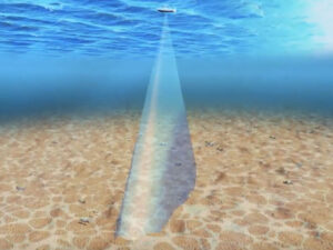
With most systems, you pass over an area to record depth details, which are cross-referenced to GPS coordinates. With your fish finder/chart plotters in record mode, the information is stored on a data card.
There are two basic ways of recording data. In the “mow-the-lawn” technique, you pass back and forth over a location in a systematic pattern to completely cover an area. The second method is a piecemeal approach that lets you build up a model of an area’s underwater topography over time.
Using Navico’s Insight Genesis system as an example, you first create a sonar log of depth recordings on an SD card in the card slot of a Simrad or Lowrance sonar/chart plotter. Next, use a card reader to upload the information to the Insight Genesis website (insightstore.navico.com). You view the updated chart via an automatic e-link. You are then given the option to purchase the chart for $19.95 or subscribe to Insight Genesis for unlimited downloads (starting at $99 a year). The updated chart is downloaded to your computer, which you then transfer to an SD card for use in your chart plotter.
To Share or Not to Share
With some do-it-yourself chart systems, you also have an option to share your updates, as well as access data that other individuals have allowed to be shared. The idea here is that hundreds of users sharing data on uncharted or sparsely mapped areas will benefit everyone. However, in some systems, you can also opt to keep your carefully gathered new depth data private and away from other boaters, such as competitive fishermen.
Equipment manufacturers and cartography companies are working to create innovative ways to make this technology a regular part of your boating experience. Some of the newly created underwater charts can even be viewed on smartphones using appropriate apps.
Humminbird’s AutoChart not only helps you gather depth data but also, when you connect a Humminbird fish finder/chart plotter to a Minn Kota iPilot electric trolling motor, allows you to automatically follow the custom bottom contours. With Humminbird’s optional side-scan imagery you can add 3-D images to the charts to reveal those hard-to-find fish hiding places.
Quick Tip
Large storms can change bottom contours. Use these systems to update charts after a big blow.
Video Tutorials
Navionics, a major supplier of cartography, offers its Freshest Data program for do-it-yourself charts. The website has a video that explains how you can use this feature. You can also view a comparison between a standard chart and one that has been dramatically enhanced using the Freshest Data system. Lowrance has posted on its site seven videos featuring Navico’s Insight Genesis user-generated cartography to show how the process works and how easy it is to use.